
")
")


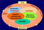
The Commission wants to advance the geo-information infrastructure by stimulating the knowledge and the research of the stakeholders. The Commission is working on drawing up her goals and tasks.
The Commission proceeds from the Commission Geo-Information Models. The occasion for the change is the decision of the NCG that after the establishment of the Commission Core Spatial Data the task of the Commission Geo-Information Models shifts in the direction of questions on the field of geo-information infrastructure and the geo-information and the geo-information technology of this field.
The Commission is working on drawing up her goals and tasks. Provisionally they are formulated as follows.
The Commission wants to advance the geo-information infrastructure by stimulating the knowledge and the research of the stakeholders. Herewith the Commission is paying attention to:
- the definition and the description of the geo-information infrastructure;
- the international context;
- input of knowledge among others in due form of best practices;
- output of of knowledge in due form of research plans, publications, seminars and opinions;
- data-input in the flow of information within the infrastructure;
- research on: a. main sticking points; b. standards; c. technology; d. retrieving.
- quality control;
- monitoring of the use and advancement of the geo-information infrastructure;
- aspects of the use and the demand for output of information of geo-information infrastructure;
- the organisation of the geo-information infrastructure.